|
|
|
Adam's Peak: The Ascent
The midnight ascent: "It's a pilgrimage, not a joyride" Ven. Dharmapala Seelananda, trustee of Sri Pada Mountain (The Sacred Footprint of Sri Lanka)
Season
The pilgrimage season runs from Unduwap poya (December) to Wesak poya
Festival (May), reaching its peak mid-season at Medin poya. At this
time, there is a constant stream of pilgrims & the top can get very
crowded. The busiest period is during January to February.
The climb is still quite possible in the off season too. However since
the path is not lit in the off season you will need a torch at night. It
often rains here in the afternoon here, especially in the off-season.
At other times the temple on the summit is unused, & between May &
October the peak is obscured by cloud for much of the time.
Pacing the ascent
All of us ought to pace the ascent so that we could endure physical
stress to avoid exhaustion. Warm clothes should be worn to avoid wind
chill & catching cold at the summit after sweating it out during the
climb. Approximately 20,000 people scale Adam's Peak on weekends during
the pilgrimage season. The endless steps can shake the strongest knees,
& if the shoes don't fit well toe-jam starts to hurt too. Hats would
come handy since the morning sun gets strong quite fast. Stretching leg
muscles before & after the climb is a good idea so that we will not be
limping for the next few days. We can have Ayurvedic oil massages too.
Routes
The three routes taken by the pilgrims who climb the Peak today are
Ratnapura route, Kuruwita route and Hatton
route.
The road to Adam's peak takes you past some spectacular waterfalls &
winds through the heart of some of the finest tea-growing country in the
world. For much of the way it is above 200m. From
Nuwara Eliya, the A7
runs through dryer country in the rain shadow of hills to the southwest
& northeast. It climbs to Nanu Oya & Lindula, where a right turn leads
up a beautiful mountain road to Agarapatana. In Talawakele, Sri Lanka's
Tea Research Institute has played a major role in improving Sri Lanka's
tea production. The road drops as it crosses the railway line & winds
through the tea estates of Dimbula. Along this stretch, there are some
magnificent views from the road. You first spy the 80m St Clair Falls,
dropping in three cascades down to the valley below. Opposite the view
point for 98m Devon Falls, an enormous bronze tea boiler introduces you
to the St Clair Tea Center, a good place to stop for a cup of tea.
Hatton is one of the major centres of Sri Lanka's tea industry on the
Colombo-Kandy-Nanu Oya (close to
Nuwara Eliya) railway & the road. 33km
by road southwest of Hatton, is the small settlement of Dalhousie. It is
from Dalhousie, the shorter (7km) & more frequently used route from the
north start. The road is illuminated in season by a string of lights,
which look very pretty as they snake up the mountainside. Out of season
you can still do the climb, you'll just need a torch (flashlight). The
approach from Hatton side is a cake-walk with steps constructed on the
path right through to the top & the base from which most pilgrims trek
to the top of Adam's Peak. It is tortuously winding route from Hatton
through Norwood up to Maskeliya at 1280 m, skirting the attractive
Castlereagh reservoir, an enormous HEP programme. If open, it is worth
stopping by the immaculately kept small stone Anglican Church (1878) at
Warleigh in a picturesque setting overlooking the tank. As you cross the
dam, which is protected by the military, & pass through the new town of
Maskeliya (the old one was flooded to make way for the tank), the
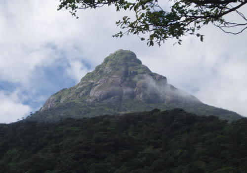
pyramid shape of Adam's Peak
Ratnapura is the starting point for the classical route to Adam's Peak
via Gilimale & Carney Estates. The southern route from the
Ratnapura
side (11km), starts from Palabadella. Many pilgrims prefer to make this
longer, much more tiring-but equally well-marked & well-lit seven-hour
climb. The really resolute & fit could climb from Dalhousie & then walk
down towards
Ratnapura, a long but rewarding day.
Plastic bags are banned from the trek, with returnable cloth bags dispensed to the pilgrims at the bridges as an alternative.
We can start the 7km climb from Dalhousie soon after dark with good sleeping bag on our shoulders to keep you warm overnight at the top. The alternative is for us wait till about 2am to start. The climb is up steps most of the way (about 5200 of them), with plenty of rest stops you'll get to the top in 2 1/2 to 4 hours. A 2.30 am start on a Poya day will easily get all of us there before dawn, which is around 6.30 am.
From the car park the slope is gradual for the first half hour or so. We pass under an entrance arch, then by the Japan-Sri Lanka Friendship Stupa, the construction of which started in 1976. From here the path gets steeper & steeper until it becomes a continuous fight of stairs. There are tea houses for rest & refreshments all the way to the top, some of which are open through the night. A handful are open out of season. The authorities have banned litter, alcohol, cigarettes, meat & recorded music so that the atmosphere remains suitably reverent.
Since it can get pretty cold & windy on top, there's little sense in getting to the top too long before the dawn & then having to sit around shivering. Bring warm clothes in any case, including something extra to put on when you get to the summit, & bring plenty of water with you. Some pilgrims wait for priests to make a morning offering before they descend, but the sun quickly rises & the heat does too, so it pays not to linger too long.
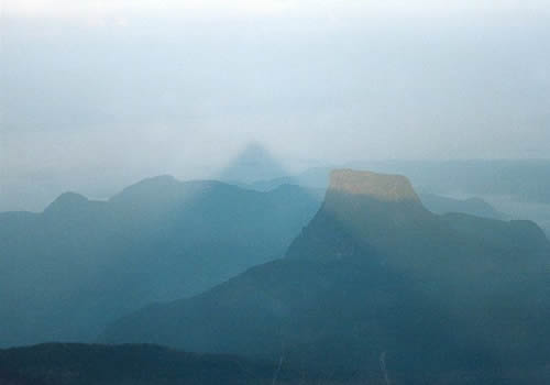
Most people do the walk by moonlight, setting off from Dalhousie around 0300, & arriving in time to see the dawn when the "Shadow of the peak" takes place. Alternatively, you could climb up the previous evening & sleep on top of the mountain, though it is very cold up here until well after sunrise so it is essential to take warm clothing & sleeping bags. Either way, it is worth ordering breakfast in advance at the Green House or Yellow House.
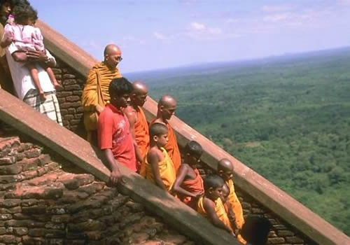
It takes about three hours to reach the top (allow an hour either way depending on your fitness). The path is clearly marked throughout, beginning fairly gently but rapidly becoming steeper, with constant steps from about halfway. The climb is completely safe, even the steepest parts being protected, & lined with teashops & stalls if you need a break. In the company of pilgrims the trek is particularly rewarding but it can be very crowded. We can notice the first-timers with white cloth on their heads.
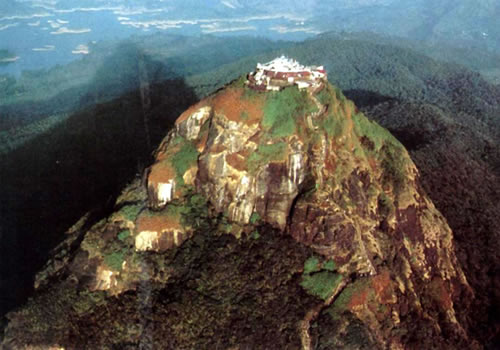
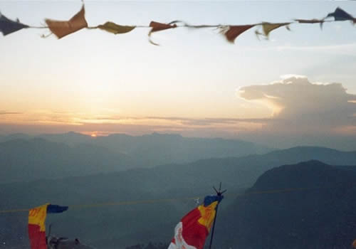
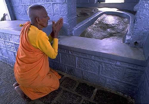
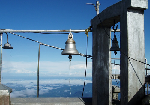
At the top, there are some breathtaking views across the surrounding hills. Steps lead up to the sacred footprint, on top of a 4-m rock, which is covered by a huge stone slab in which has been carved another print. Pilgrims cluster round, throwing offerings in to the 1-m hollow, before moving to the Saman shrine up another flight of stairs where thanks are given. Pilgrims who have made the trip more than three times then ring one of the two bells at the summit, each chime representing a successful ascent. There are three official processions a day-at dawn, midday & dusk-with music, offerings & prayers, though many people perform their own ceremonies at other times
Instead of returning to by same northern route to Dalhousie, we can descend by southern route to Palabedella & travel to Ratnapura, a long but rewarding day.
Adam's Peak (Sri Pada) & Peak Wilderness Sanctuary
Horton Plains national Park borders the Peak Wilderness Sanctuary, a crescent, 40 km (25 miles) swathe of montane forest that can be approached from Dalhousie, 25 km (15 miles) west of Nuwara Eliya - Colombo Road, or from Carney, 8 km (5 miles) north of Ratnapura.